Yesterday I grabbed the opportunity of a break in the almost constant rain to seek out a scrap of wreckage from Avro Anson Mk.21 VV955, which crashed in low cloud on Foel Lwyd on May 20th, 1959. It felt like a relatively unambitious walk on a day which had been filled with alternating fine and heavy downpours.
I also discovered that Foel Lwyd is a popular name in these parts. This Foel Lwyd forms the end of the ridge of Tal y Fan, while another Foel Lwyd stands behind Pen y Castell on the other side of the pass of Bwlch y Ddeufaen, which separates the two identically named peaks.
On the way up to find the piece of wreckage I also passed a small slate quarry; small, but surprisingly large considering no sign could be seen of it from the road.
The land I crossed to reach quarry, plane wreckage, and the peak of Foel Lwyd is Right to Roam, but there's no footpath. Always respect the farmer's land, leave gates as you found them, don't drop litter, and take care not to damage fences or walls. Keep dogs on a lead no matter how well trained. Leave nothing and take nothing away that isn't yours.
A lightly used track runs up the hill directly past the quarry and plane wreckage but peters out before the peak of the mountain. I found the last bit heavy going through knee high springy heather and bilberries. There were still a few late bilberries to eat, sweetening the occasional fall into the heather. Really, Foel Lwyd is a peak to achieve for the sake of ticking off another mountain, rather than for the majesty of its existence.


A trailer lies abandoned in the field not far from the gate to the road. We used to ride on a trailer like this to help with the haying in the valley, hanging onto the metal as it bounced down the lane behind the tractor, then ride back on top of the load, high above the cars.

A mushroom grows in the lush grass, serene under the sun.


 The quarry is clearly marked on the 1888-1913 map as an old working, and it looks as if it disturbs an earlier boundary. Map image from archiuk.com.


 Fat bilberries grow beside the wreckage, but they were at the peak of their taste a little earlier in the year.


 Finally on the way down, near the stile by the high pass between Tal y Fan and Foel Lwyd.

The slate tip was larger than I expected from the quarry outline on the Ordnance Survey map. The whole quarry area centres on Ordnance Survey Grid Reference SH 7258 7180.

The quarry sits in a clearly delineated enclosure between straight walls. The walls are in good order up here, and it's hard to tell whether the quarry or field walls are older. I'd guess the field walls (not the detour round the tip) came first, but could be completely wrong.


The slate tip is becoming lost under heather and grass, which seems to indicate a good deal of time passed since it was last active. In the distance you can see the rounded shape of Pen y Gaer, and the Conwy Valley beyond.

A little spread of thinner slates near the foot of the tip.

On top, the tip is almost indistinguishable from the natural land.

The remains of a small structure on top of the tip.

The entrance to the working is just visible behind the tip as a gully in the hillside.

Nature is overtaking the scar, but there's still slate debris on the surface.

Once you've navigated the little gully, a sizeable quarry working opens up.

More slate scree not yet overtaken by nature.

We climbed out of the lower quarry working, using heather for handholds.

Above the larger working is a smaller one which doesn't open up like the other. I saw a fox running off through the heather, a red flash against the purple flowers.

This higher working peters out into nothing.

Looking out over the lower working, slate tip, and the valley beyond.

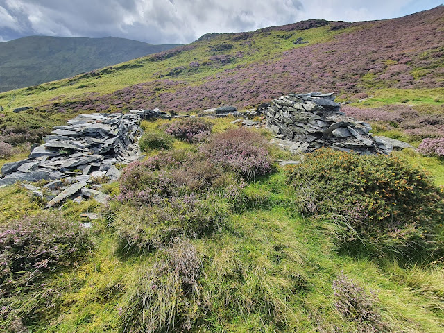
Near to the workings are the remains of a small building. I assume it was associated with the quarry since there are no other buildings nearer than this.

This building is in a very ruined condition, so it's hard to tell what it might have looked like originally.

The ruined building with the hill rising behind it.

There are some nicely dressed stones in the ruin, so it's reasonable to assume it was a good looking structure.

Following the light track a little further up the mountain brings you to a flat little shelf of land, a peaceful looking space on the mountainside. This is where the wreckage of Avro Anson Mk.21 VV955 is located, near to where the plane crashed in cloud in 1959, killing a crew of three. More details can be found at the Peak District Air Crashes site. The wreckage is located at Ordnance Survey Grid Reference SH 7237 7204.

This is all that remains, one of the plane's undercarriage oleos, with a couple of metal bars next to it. My uncle recalls exploring the wreck site in the years immediately after the crash, believing it to be a WWII crash, and finding many panels from the body of the craft. Neither he nor my mother remember hearing about the crash when it happened.
A number of photos of this piece of wreckage follow, which need little comment. Visiting these places is always a sombre experience, somewhat like visiting a grave. I like to look deeply but not disturb anything permanently, placing anything I move back as I found it.


***


The tiny bit of wreckage can just be seen in the centre of this photo, with the slopes of Drum rising beyond the bwlch between the mountains.

Finally on top of Foel Lwyd, after a struggle for the final few hundred yards of springy mountaintop plants. It feels something of an anti-climax, not as peaky as it looks from below, and bisected by dry stone walls.

The views from the top are wonderful, if you can see over the walls. In the distance is Anglesey, as well as Puffin Island just in the far right of the photo.

Looking north, you can look out over Penmaenmawr and Llanfairfechan to the limestone hump of the Great Orme, with Llandudno lying low to the right.

The path is much better on the other side of the wall. Luckily the wall has been built with a lot of protruding stones, so, with a little care, it can be climbed.

On the other side of the wall lies a well trodden path, and the peak of Tal y Fan rising as a rocky lump in the distance. From here, it really is a distinct mountain from Foel Lwyd.

I have been to many of the aircraft crash sites in Snowdonia, after reading 'No Landing Place' by Eddie Doylerush. I have yet to go and find this Anson crash site, maybe one day. Thank you for posting your walk and for the photographs.
ReplyDelete