I have wanted to go and find this stone circle for a long time, having heard about an impressive stone circle up above Penmaenmawr on the coast. Previously I've only seen very small stone circles in my area of the Conwy Valley, with stones no more than about a foot high. Y Meini Hirion really is a notable circle, though. It's no Avebury, but it does have stones as much as five feet high, and there are eleven stones still erect (of thirty original stones that were standing, according to the
Snowdonia Heritage website. This website contains a nice brief history and description of the site, while the
Megalithic Portal site contains less history but more photographs and location information.) The circle was apparently erected between about 1450–1400 BC, but it could be much older. Two cremation burials of children estimated to be in their very early teens were found during excavations in the 1950s. The circle is not in isolation. A trackway runs to the side of the circle, probably pre-dating its construction, and the hillside about is littered with other prehistoric monuments, with a
ring cairn perhaps about fifty feet away to the west (I'm not good on estimating distances), and a
second stone circle (low and invisible from Y Meini Hirion - we didn't see it at all) a little to the south. There is also a
neolithic axe factory nearby, and various other monuments, all listed on the
Megalithic Portal.
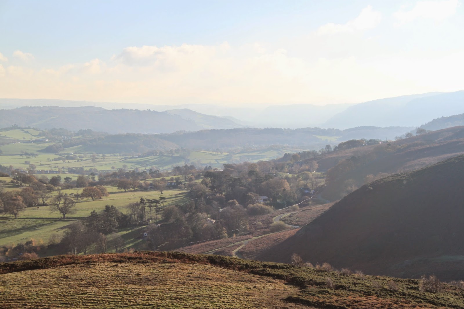
We approached the circle from Llanfairfechan, which by all accounts is a longer route than from Penmaenmawr, but perhaps a more gentle one. We needed the sat-nav to get up to the path by car, but after that it was a quite straightforward walk. Most of the way was along a grassed-over farm track (you enter the fields through the farmyard, which had a rather attentive sheepdog on duty) which was relatively easy to traverse, and not very wet. It's a very pretty walk with views over to the Menai Straights and Anglesey and then to Llandudno and the Great Orme as you get closer to Penmaenmawr, and took less than an hour each way, including dawdling to take photographs. The circle is off to the right of the track, though, and we spent a bit of time wondering if we were in the right place before we found it. My husband saw one of the stones on the brow of the hill, and so we found it. The circle is rather tucked away, though, hiding behind a little ridge, so that it's more or less sheltered from views of the coast.
 |
The view from where we started, up above Llanfairfechan, back towards the hills in the west.
|
 |
The path starts off along a rather idyllic farmer's drive.
|
 |
The track becomes rougher, but the views get more stunning. You can see down towards the Menai Straights and Anglesey.
|
 |
This is rather a lovely shallow valley leading down towards the coast.
|
 |
| This is a lovely old track and reminds me of the Roman Road (or adjacent track) through Bwlch y Ddeufaen above where I live. I assume due to its depth in the ground it has quite a bit of age. |
 |
| Lovely dry stone wall and mountain beyond. |
 |
Typical Welsh sheep.
|
 |
| A little square enclosure in the middle of a field, with an old bath (you get lots of old baths being used as water troughs) and some other stuff. Hard to know if it's an old dwelling or a sheep fold or some such thing. |
 |
| Our first look at something that may be prehistoric. I really don't know, but it looked like a deliberate arrangement of stones. |
 |
| This stone appeared to have some kind of circular carving on it, but again, it's hard to tell if this is something of significance or just a coincidence. |
 |
| Those stones from the eastern end. The one with the circular pattern is the one in the middle jutting up. |
 |
| Some more anomalous heaps of stones, possibly ancient, possibly more modern. It's very hard to reconcile what we saw on the ground with looking at maps later. |
 |
| Again, another anomalous feature with lots of very large stones spread very far apart. Is this some kind of very wide circle or just some stones on a hill? |
 |
| A couple more of those large stones that appeared to be in a big circle or something. |
 |
| And more of those stones. |
 |
| Eventually we got to where we were were sure Y Meini Hirion should be, but were failing to find it. You can see the Great Orme in the background. I'm not sure which mountain we're looking at in the centre here. |
 |
| Eventually my husband spotted what looked like a single standing stone up on a ridge to the right of the track. We made our way up there to find this ring cairn, with Y Meini Hirion just beyond to the right. |
 |
| The rather jumbled looking ring cairn near the stone circle. |
 |
| The ring cairn from another angle. |
 |
| And from another angle. I assume the two horizontal stones on the left were placed like this rather than fallen. |
 |
| Yet another view of the ring cairn, looking rather bigger and more impressive. |
 |
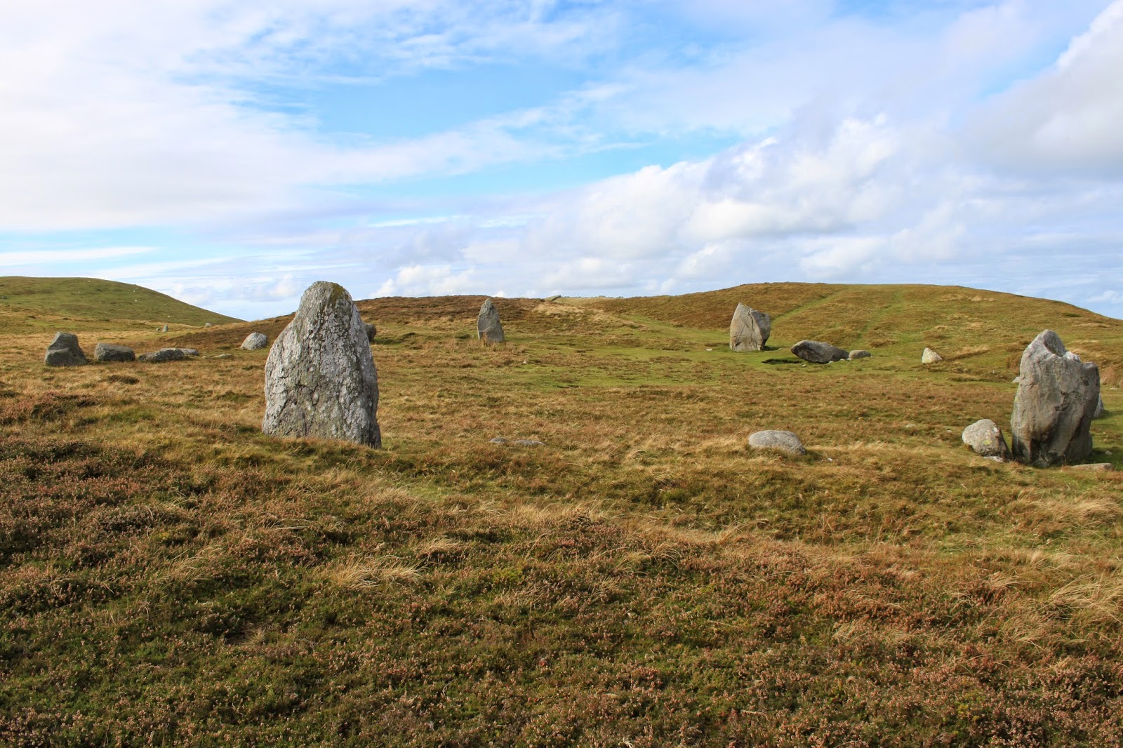
| And then we approached the circle itself, an impressive wide ring with a lot of space in the centre. There appears to be something of a bank and ditch around the outside. |
 |
| One of the stones had some rather impressive cracks or marks on it. Someone had also been up and painted a crucifix on one of them in silver metallic paint, which is either vandalism or a nice continuity of using religious spaces, depending on how you look at it. |
 |
Some kind of deliberate arrangement of stones here, I think. If only I were an archaeologist, although on my one foray into archaeology in an academic context I was labelled as pessimistic.
|
 |
| Again, that arrangement of stones, the five foot tall one with two smaller roughly spherical ones either side and a smaller roughly spherical one behind must be deliberate. |
 |
| Another view of the circle. |
 |
| And another, looking back west, I think. |
 |
| I seem to be a bit obsessed with this stone. Is it very phallic or is it just me? |
 |
| From the south side (roughly), looking north. The circle really is hidden from the view of the sea, and the path down below, by the little rise of land to the north. |
 |
| I'm not entirely sure if this is the remains of a ditch round the circle or just a path, or a ditch that has been used as a path. |
 |
| From this side of the circle you do get a rather nice view over towards the Great Orme (site of a Bronze Age copper mine) and Llandudno. |
 |
| Well, if the other stones looked rather phallic, this one looks like it's giving someone the finger. |
 |
| A full view of the circle from the north-western side (the side closer to the sea, at least.) |
 |
| A final view of the ring cairn as we made our way back home. |
 |
| Looking back toward the circle on the way back, and you can see why it was rather hard to find. It's up behind the hills on the right, not visible from the path at all. |