Tyddyn Grasod is actually two little adjoining houses, one more modern than the other, just on or above the edge of the ffridd near Llangelynin Old Church. I visited here as part of a long circular walk around Tal y Fan on a bitterly cold day in February 2021 - so cold that it was physically painful to take my gloves off to take photos, so cold that my phone couldn't charge from my battery pack. The land around the mountain was covered in sheets of ice. Some additional photos are from February of 2023.
Although quite reachable by a tarmacked road which leads very near the property, there isn't nearby parking, but there are plenty of nice walks and bridle paths in the area, with a scatter of prehistoric remains and wide moorland nearby. There is a small amount of parking near Llangelynin Old Church, from where you can walk across to the house (the church itself is very worth visiting). The place is one of a handful of abandoned cottages in this area, although the upland in this small part of the valley has been lucky in retaining a lot of its high-altitude houses. The house lies very near to a footpath, but isn't directly accessible, and was visited with permission.
See a video of the house here, and a more recent video here.
The house is at Ordnance Survey Grid Reference SH 74463 74700.
The view of Tyddyn Grasod from the south.
The left end of the house is probably the older part and, sadly, is much more ruined. The right end is likely the newer addition. Both halves would have been cramped living accommodation for large families. Both chimneys, at opposite ends of the building, have collapsed.
Nearby houses share the name of 'Ty'n y Ffridd', but whether or not Tyddyn Grasod is on or above the ffridd is probably dependent on your feeling for the word. The
Geiriadur Prifysgol Cymru translates
ffridd or
ffrith as 'moorland; frith, rough mountain pasture, sheep-walk; woodland, forest, park.' Tyddyn Grasod is very much above the woodland, but is set in rough mountain pasture, on the edge of moorland, just above 300 metres (984 feet). The Welsh word 'ffridd' actually derives from an
Old English word generally associated with wooded areas.
The name Tyddyn Grasod itself is a bit of a mystery. Tyddyn means smallholding, but Grasod isn't obviously cognate with any modern Welsh word. Christopher Jordan, in his archaeological report "Tyddyn Grasod" (Caernarvonshire Historical Transactions Volume 48: 1987) reads the name as 'Grasaidd' in the tithe. He must be looking at a different record from the one I have seen, as the word is clearly 'grassod' in the one available online, but the house is named as Tyddyn-crasaidd on the 1892-1914 Ordnance Survey map. Jordan also states that the place was occupied by William Roberts, with a 2 acre smallholding, while the 1848 tithe record lists William Roberts as occupying 2 roods, 5 perches, and Elizabeth Roberts as occupying 3 acres, 3 roods.
Jordan suggests the name may be connected with 'gras', meaning 'grace', and that the land may at some point have been gifted to the church. He also raises the possibility of 'cras' (the 'c' would be mutated to 'g'), a word related to baked, arid, harsh, or scorched. Suggestions shared with me online in the Facebook group
Iaith have given a range of possible meanings covering these options, as well as suggesting a connection with airing, 'crasodyn', referring to kiln dried corn or a lime kiln, 'crasu' referring to a bakery, 'crasog' meaning rough or harsh. These are fairly similar suggestions to Jordan's. Is it possible there was once a kiln on the land? It was also mentioned that 'crasod' is a word used for hail in the Dolgellau area, which is the closest in spelling to the house name, but out of area for the meaning, unless this word was also used locally. 'Crasod' meaning hail would certainly be fitting to this upland area.
It may be that the meaning of the name is just lost to time.
Wonderful dry stone walling lines the tracks in the area. Tyddyn Grasod sits right on the edge of the enclosed farmland; behind it the moorland spreads without walls all along the back of Tal y Fan towards Llanfairfechan. Locally the place is also known as Llidiart Mynydd - the mountain gateway.
Despite the proximity of Llangelynin Old Church, the house actually sat in Gyffin
parish for most of its life - designated as Gyffin Lechan from the 1841
census onwards, until it was listed as Gyffin in 1891, and became
Llechwedd in the 1921 census. The house saw changes in the occupation of
its residents through the years as society changed, until it was finally abandoned.
The left, southern, end of the cottages is showing a lot of damage, and most of the roof has collapsed. It won't be long before the place is too far gone to save, which is extra sad because there are people willing to save it if only they had permission. The front gateway obviously hasn't been used for a long time. The fireplace end of the house is evident in the large amount of wall at the left end, with the windows and doorway set asymmetrically towards the right end.
Mentions of the cottage in the parish records are scarce, but this is compounded by the scanty availability of the Llangelynin parish records (the closest church), which are mostly missing before the 19th century, so it's hard to know how old the dwelling here might be. Perhaps looking at the Bishop's Transcripts (copies of the parish records) would be helpful but because I haven't yet investigated them I don't know if they preserve details such as abode, or just the bare details. I have found a few later entries for the place in the Gyffin parish registers but nothing in the earlier records, although house names are rarely recorded in these. I do wonder if the inhabitants might have used Llangelynin Old Church until the New Church was built in the Georgian era, at which point perhaps getting to Gyffin church would seem as easy as getting to Llangelynin New Church.
The house doesn't appear at all in the older newspapers available on the
Welsh National Library site, or in wills online. The place doesn't appear to be mentioned in local non-conformist baptism records, either.
Looking towards the newer, northern end of the house. The little walled garden seems to stop just past the end of the older house.
Coflein describes the house as being built of quarried stone with mortar binding, while Jordan describes it as stone gathered from the moor.
A North Wales Weekly News article from 21st June, 1962 (p. 8, by 'Gleaner') dates this part of the house to 1830: 'Parishioners borrowed of William Pierce (or Price) the sum of £200 "to build new homes for the use of the poor of the parish"' part of which was for '"building a new house and repairing the old house at Tyddyn Grasod"'. How old the 'old house' was at the time is a matter of conjecture. Old enough to need repairs, at the very least.
The fact that this house was being built for the poor is perhaps reflected in the small size of the accommodation. It also shows an interesting change in social housing - now no local authority would dream of building housing for the poor in such a remote place. This is a liminal place, a place where it's not necessarily easy to live, even if you are cutting peat for fuel from the moors behind the house and growing most of your own food. Even if the church is a short walk over the fields, in the wintertime it's a harsh place, but in 1830 most of these upland areas were being lived in and farmed. Our attitudes and methods towards how we live with and from the land have changed vastly in two hundred years, and could change again with the advent of high speed internet and different ways of accessing services.
Interestingly, the tithe records from 1848 show the land as belonging to Gyffin Parish. I'm not sure if that means that this was originally part of the unenclosed land. Does unenclosed land belong to the parish? This might explain, though, why they were able to build and repair homes for the poor on this land, and why this house is right on the boundary between the enclosed and common land.
At this time the land was used by two occupiers, William Roberts and Elizabeth Roberts, the tenants of the two separate houses. As we will see later, Elizabeth Roberts must have been fairly recently widowed, since she is married in the 1841 census. William Roberts is recorded as occupying Tyddyn Grasod - two roods and five perches, on the map appearing not much more than a garden. Elizabeth occupies a larger part of the same, three acres three roods. While William owes no tithe, Elizabeth owes eight shillings. It's obvious that at this time in history the use of the land around the house was very meagre and, looking at the subsequent censuses for the property, it doesn't seem that this ever expanded beyond the use of about four acres (adding the two tithe amounts gives four acres, one rood, five perches) which probably accounts for the land immediately around the house.

The doorway into the newer house, with a very thin lintel over the top, and a blocked window almost imperceptible on the right. It's interesting that the garden wall neatly curves in to the left of the door, but to the right of the window in the newer house. Does this imply that previously there was some kind of building or enclosure on this end of the older house which has been incorporated into the newer house? It could just be that the wall was altered later.
Christopher Jordan must have had the benefit of visiting the house when it was far more intact, still possessing its roof on both segments, and both chimney stacks, as well as some flooring, interior woodwork, and cast iron guttering. He mentions the blocked front window and wonders why this was done apparently long ago, since it blocks the only light into the room except from the door. Blocked windows are often seen in these abandoned buildings and it's always seemed likely to me that this occurs when the place falls out of use for living but is still used for animals or storage, since it makes the place warmer and easier to maintain.

Inside the newer house, which has a rather curious fireplace in that the ends of the lintel don't seem to be resting on anything! This fireplace is rather smaller than the ones often seen in older houses, but neither house has by any means what would be called an inglenook. The chimney breast angles inwards in L shapes at about first floor level. Was there ever a platform at this level, or perhaps shelving?
The right side of the chimney breast.
The left side of the chimney is quite collapsed but you can still see the reverse L shape here.
A scatter of plaster and slate debris lies on the floor, mixed in with sheep droppings turning to soil. The roof has at some point been reinforced with mortar, which maybe made it last longer, but also must make it more vulnerable to collapse once the rot has set in. Jordan concludes that the floor in this newer house was never more than packed earth and some irregular stone slabs. The slabs must be lost under years of sheep droppings.
To the left of the fireplace a small amount of brick is all that's left of a bread oven, recorded by Coflein in 2004. See a photograph of it
here, where photographs show the deterioration of the property including the chimney, intact in 2004 and gone in 2018.
It's interesting to see this bread oven, which Coflein states is later, built outside of the fireplace, implying that in 1830 when the extension was built, a bread oven wasn't considered necessary. I don't know if the chimney from this bread oven was knocked through into the main chimney, since there seems to be no sign of a chimney from it in the Coflein exterior photograph. It could be that this weakened the chimney and caused its later collapse. Jordan's article shows the bread oven protruding from the end wall in an igloo shape, but there is no sign of a chimney coming from this domed structure in his diagram.
The bread oven from outside, looking rather roughly built against the house wall.
The oven seems to be completely filled with rubble. The house wall is so unstable that any further investigation would seem unwise.
Looking down onto the top of the bread oven, which presumably used to have some kind of top.
The underneath of the roof, with what looks like large wads of clay filling a gap between the top of the wall and the edge of the roof.
With the parish records for Llangelynin being so scanty, and having not checked all of the Gyffin parish records yet, most of the details I have for this property come from the census returns from 1841 onwards. Since the newer part of the building was already built by this time, it's not surprising that two families are listed in the property. The heads of both of these families in 1841 were agricultural labourers. Considering the earlier house was repaired and the second built for the poor, it's reasonable to assume these were poor families living here. A site
here lists a British weekly wage for an agricultural worker in 1850 as 9s 3 1/2d, an equivalent of around £37 today, which would seem like a very low wage.
In 1841 the two houses contain ten people in total. In one house were John and Elisabeth Roberts, both 55, he an agricultural labourer. They are living with William Roberts, 25, also an agricultural labourer, Elisabeth Roberts, 15, Sarah Roberts, 11, and John Roberts, 5. All were born in the county but the census doesn't tell you how they were related to one another at this point. The second house contains William Roberts, 55, an agricultural labourer, Anne Roberts, 55, Jane Roberts, 14, and Mary Hughes, 11, all born in the county. It's impossible to know which house each family lived in, but whichever it was it means that the smaller and newer house would have contained at least four people.

The chimney, always a weakness in these buildings, is extremely precarious and unsafe. If the side of the chimney was altered to take a flue from the bread oven, and if the end wall beside it was also knocked through to create the dome shape of the bread oven, this might account for the amount of collapse in this area.
By 1851 the families have changed a little. It seems likely that John Roberts has died, because Elizabeth Roberts, 65, is listed as being a pauper widow, born in Llandegai. She's living with her grandson, John Jones, 15, an agricultural labourer, and grandson Richard Davies, aged 6, both born in Gyffin parish - which, of course, is the parish in which the house sits, spreading all the way down to the modern outskirts of Conwy town. The second house is still lived in by William Roberts, 66, an agricultural labourer but also a pauper, born in Llangelynin parish, wife Anne, 68, born in Caerhun parish, and Catherine, a 13 year old listed as a house servant, born in Llanllechid. It's more likely that Catherine is a relation of the couple and her role is that of a servant, rather than that a pauper couple are paying a servant.

Looking towards the front door and the blocked up window, showing how narrow this main room is. The carefully blocked window will probably help to preserve this front wall a little longer.
Looking up the very precarious chimney.
At the back of the main room is a little niche in the wall, but I'm not sure if this is a deliberate little shelf or where a stone has fallen out. There seems to be a hole right through to the back of the wall, but it's possible this was once a small cupboard or shelf.
The doorway into the second room, which is extremely low, even accounting for some raising of the floor level, and quite narrow. I am 5'3" and the top of the doorway came up to my chest
Jordan describes this second room as 'tomb like,' and doubts anyone slept here, but he doesn't seem to have had the benefit of seeing the census details. What does seem baffling is that this very solid stone wall was built instead of a wooden partition with a sleeping platform above, which would seem easier, cheaper, and would give more room in the house. It's also baffling that the doorway was made so small. Could it be that this part of the building was once an outbuilding, altered to make it into the second home? Even if it were, the proportions still seem odd.
(The tent inside is not evidence of high altitude homelessness, but something left behind by a lad at some point.)
Detail of the wall, showing plaster and whitewash in layers.
A rather beautiful view from the partly blocked window of the second room, over towards Cerrig y Ddinas, site of a prehistoric hill fort.
Some parts of the roof are more intact than others, but with a gap like this rot will start setting it. It's interesting, though, to see the curved tops of the slates
The roof is supported by joists and very thin, rather random looking laths. Since the later part of the building was built in about 1830 it seems likely it was always slated rather than thatched. It's hard to know about the older part without knowing its age.
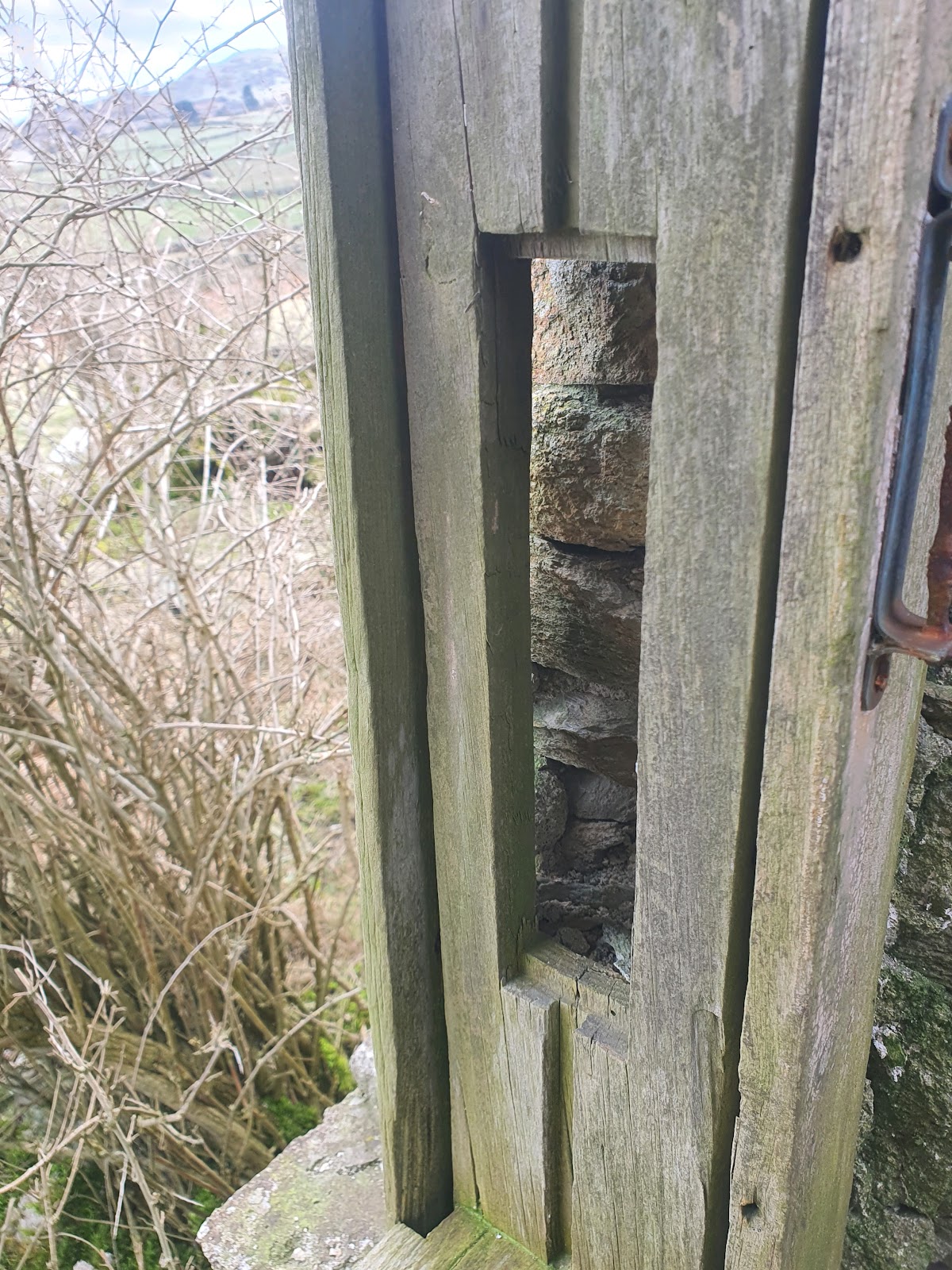
A blocked up window high in the wall of this second room is actually a window for the croglofft of the adjoining house, which must have been blocked up when this extension was built. It must have made the croglofft considerably darker to use. There don't seem to be joist holes for a first floor in this small room.
Looking back from the second room into the main room, you can see how low the doorway is.
Heading towards the older half of the building, and there's a little gateway at this end of the garden.
By
1861 it seems that only one of the houses is lived in, or that one
household has spread out to occupy both homes. It continues this way all
through the rest of the censuses, so the second house built for the
poor may have had a relatively short life in that role. It's impossible
to tell, of course, which of the houses was being used as the main
residence, and there's the caveat that the census is only a snapshot of a
single night - the second house could have been occupied every other
night of all of those years. However, taken with Jordan's idea that
the window in the newer house has been blocked for a long time, perhaps
the house was quickly judged unsuitable and turned into accommodation
for animals. It seems highly likely that it was this older house that was occupied, instead of the newer.
It
seems that the fortunes of the residents are slightly better now. The
head of the household is William Owens, 39, a farmer of three acres and a
stone quarrier, born in Gyffin parish. Presumably his farming is more
of a smallholding, providing some food and other goods for the family's
use, and this rural world is starting to be more affected by the spread
of industrialisation.
There
are a number of quarries where William could have been working, with
the Tal y Fan quarry very close to the house, and the Penmaenmawr quarry
not far away. His wife Catherine is only 25, born in Dwygyfylchi
parish, and they have four children, 5 year old William, 4 year old
Elizabeth, 2 year old Moses, and one month old Mary, all born in Gyffin
parish. Neither Mary nor Moses appear in the Gyffin baptism records, although the family's other children do. Daughter Elizabeth was baptised on 24th February, 1857, son
John on 7th April, 1863, daughter Hannah on 27th December, 1864,
daughter Anne on 20th November, 1868, and Catherine on 21st December,
1870.
It's possible that Moses Owen is the same boy who is working in the 1871
census as a 12 year old farm servant at Trwyn Wylfa in Dwygyfylchi. In
1881 he is probably the General labourer of 22, married, with two
children, and living in Tan y Graig, Dwygyfylchi. Mary Owens is harder
to trace.

Although this half of the building is in worse condition in some ways, it does still retain things like a window frame and a certain amount of timbers from the roof and inner structure.
Above the left hand window in the older house there are clear signs of an upper window, including the wooden frame. If the croglofft platform was at the right, northern, end of the house, then why is there a window here? Was the whole building once given a first floor, or is this just to provide more light?
Brickwork in the window opening below. I wonder if this formed part of the repairs made in 1830, or if perhaps they came later.
The doorway is partly obscured by some kind of thorny shrub, evidence perhaps of ornamental planting. I'm not great on identifying plants, especially when they have no leaves! The top of the doorway is constructed with a couple of lengths of wood, one of which is starting to collapse. Evidence of a porch can be seen on the right side above the door. During his survey Jordan found ceramic tiles in the doorway, describing the interior floor of the house as being of 'packed earth, beneath mortar-set plain and unglazed earthenware tiles'.
The floor inside is littered with slates from the roof collapse, and there aren't any signs of the tiles mentioned. Hopefully some still exist below the rubble.
Looking through the window from inside.
In
1871 the same family are still living in the house. William Owens is
now 51, and listed as a farmer of four acres, so the family have
apparently gained an extra acre of land and he's no longer working in
the quarry. Wife Catherine is 35, and they're living with children Mary,
10 (the only remaining child from the previous census), John, 7,
Hannah, 7, Ann, 2, and Catherine, 6 months. By 1881 Catherine, 44, is
widowed, still a farmer of four acres; her husband William was buried at
Gyffin parish church on August 16th, 1879, aged 59. Son John, now 18,
is a setts maker in the stone quarry. Anne is 12, and Catherine is 10.
You can see a drawing of a sett maker at work
here (do explore Mary Elizabeth Thompson's other atmospheric quarry artwork). The setts would have been used for paving streets and pavements. It's hard to imagine it as anything but back breaking work.
In
1879 Elizabeth Owen of Tyddyn Grasod married Elias Jones of Bodidda,
labourer, son of William Jones. Perhaps in the 1871 census she was, like
her brother Moses, working away from the home as a servant, but I can't
find her in a local search.

A closer look at the sash window frame. If it was ever painted, the paint hasn't survived. I'm not sure what the metalwork to the right is.
In
1891, the situation is rather intriguing. John Owen, 25 and single, is
the head of the household. He's living with his widowed mother,
Catherine, 55, daughter Catherine, 20 - this is the elder Catherine's daughter and
John's sister - and 'son' Peter, 5. Whose son is Peter? It seems
unlikely that the widowed Catherine bore him at age 50. Both her adult
children, John and Catherine, are listed as single. Catherine senior and
her husband William had their children baptised in Gyffin parish
church, but daughter Catherine is the last one in the records available,
in 1870.
There
are suggestions in the parish records that the second house may have
been lived in at times between the censuses. William Owen's burial is
recorded in Gyffin on 16th August, 1879, but there is also the burial of
Henry Roberts of Tyddyn Grasod, aged 4, on 26th June, 1877. Possibly
there was a Roberts family living in the second house at this time,
unless this was a child of one of the daughters of the household, or some other relative. There
is the birth of a Henry Roberts recorded in Conway district, born in the
first quarter of 1873, where the mother's maiden name is Parry.
Sometimes records cast up more questions than they answer.

Above the window, it looks as if there was once another window directly above it, probably to light the croglofft, which would have made the blocking of the window in the gable end a bit less of an issue. Jordan mentions a skylight in the roof, which may have been put in when the gable window was blocked.
By
1901 John Owen, 38, is married to 36 year old Jane Owen, and they have
a seven year old son, Robert William, four year old daughter Jane, and
one year old daughter Mary Elizabeth. Both parents are bilingual while
the children speak Welsh only, implying this is the only language spoken
at home. John is working as a lead miner and farmer, presumably in the
nearby lead mine. In 1911 John Owen is now a setts maker, making square
blocks for paving, as is his oldest son Robert William, now 17. I don't
know if setts making is a healthier occupation than lead mining, but it
seems it should be. Daughter Mary Elizabeth, 11, is at school. Daughter
Jane isn't mentioned, but they do have another son, John, who is five.
One of their five children is recorded as having died, but only four
have made it into the censuses. All are now bilingual except for five
year old John. There are three rooms in the house.

Some of the joists from the roof have collapsed into the building, but what's more unusual is the survival of the edge of the croglofft platform.
The
final census available is for 1921, and the house is still being lived
in, but by a different family. The head is John Roberts, 70 years and 6
months old, a retired lead mine labour who was born in Geirionydd Tal y
Llyn. Wife Mary, 50 and 10 months, was born in Penmaenmawr. With them
lives Daisy Roberts, a 15 year old orphan born in Llandudno. All are
bilingual, and the house contains three rooms. Daisy seems like a rather
unusual name, but there are a number of Daisy Roberts in the local area
and born around the right time who turn up in the records, and it's
hard to know if Roberts was her original surname or a name taken from
the couple she's living with. If she later married she will be even
harder to trace in subsequent records.
Tyddyn Grasod doesn't appear in the 1939 register, so it seems likely it was unoccupied by this time.
The right hand, southern, window looks as if it's bowing at the top with the weight of the wall, and no window frame survives.
More collapsed roofing timbers.
Detail of one of the roofing timbers, with a wooden peg.
Iron has been used in this part.
Another roofing timber detail.
A very small amount of the roof survives here at the corner, as well as plaster on the wall above the fireplace
The fireplace is pressed up against the front wall of the house, with a nook at the right side. A small amount of a cast iron oven system survives, but it's partly buried in rubble. Jordan recorded an 'extensive but badly damaged cast iron kitchen range'. Notice the bricks to the left, possibly out of the fireplace. There are two holes drilled in the beam, probably for metalwork or hooks.
Sometimes nooks to the side of the fireplace were used as a dairy, although this seems fairly narrow. It could have been used for shelving, but not enough of the plaster survives to see the ghost of shelves. Jordan states that the nook 'shows evidence of having been a large walk-in cupboard'.
A closer look at the bricks near the fireplace.
The brittle cast iron oven is quite damaged.
The back of the chimney is built of quite small, shoddy-looking bits of stone. The blackening on the stone may be soot.
Looking up the chimney, which is collapsing in on itself at the top.
The shaft seems to get quite narrow at the top, and looks very unstable.
A small nook in the left side of the fireplace. This is far too small to be a bread oven, beside being fronted by the beam, so a fire couldn't have been lit in it. It seems likely it was a place for storing things that needed to be kept dry, like salt. There's no sign of a bread oven in this fireplace.
The back left corner of the fireplace.
A view of the back of the beam supporting the chimney.
This section of roof has fallen as one piece, connected by the heavy render that was put on the outside at some time. Having just had a discussion about these slates online, it seems likely these were pre-1800, and would have been secured with an oak peg through the hole at the top.
A wide angle shot towards the croglofft end of the house shows the remaining beam from the croglofft platform and the joist holes that would have supported the other end. It would have been a low space, but a usable one. It's interesting how yellow the stone looks in this house, compared with the rather greyer stone further up the valley.
When Jordan visited in 1987 it sounds as if there were more remains of this croglofft platform, as well as evidence of a post and panel screen below, segmenting the living area downstairs into two rooms, and possibly evidence of a similar screen for the loft above. He also mentions several layers of wallpaper wrapped around some of this wood, so perhaps at one point these wooden screens were papered. I have seen similar
wallpapered wood in
Siglan in Cwm Cowlyd, and whitewash and paint on a screen in a different house, which suggests that at some point householders were seeking to lighten or brighten the dark wood in their houses.
Looking towards the left of the platform. The ends of the roof joists still seem to be in their original position.
Looking towards the right side of the platform, where none of the roof joists have survived. It's interesting that the gable end window abuts right onto the edge of the wall at the right.
What seems to be thick whitewash and perhaps soot on the side of the fireplace.
More layers of plaster and limewash on top to the right of the fireplace.
Looking out through the doorway.
A close up of the timber forming the front of the croglofft platform.
A closer look at the timbers forming the top of the front doorway.
Although it would have been harsh living up here at times, the view from the front gateway is beautiful, and there are plenty of neighbours.
Outside the south end of the house, looking at the gable end of the older part.
Looking along the back of the house.
From the back you can see that it's not that a row of slates has fallen from the roof, but that the entire slab of roof, reinforced with mortar, has slipped as one. Considering this housed two households, the place looks very small from here.
A deliberate gateway between the back of the house and a small wall abutting an outcrop of rock. The limit of the enclosed land isn't far away to the left.
You can see the join between the two buildings at the back here, and the reinforced slab of the roof above.
This stack of slates must have been removed at some point, perhaps from one of the ruined outbuildings.
Looking towards the north end of the house, you can see the great cracks in the wall in the gable end where the chimney has collapsed, as well as outbuildings built into the ground at this end, and on the other side of the track in front of the house. To the right hand side of the house wall you can see the curved outer wall of the bread oven.
Back on the track that leads past the house.
The lowness of this little door leading from one chamber to another reminds me of the lowness of the door inside the extension to the main building. The construction of that main building does seem intriguing. Why build a solid stone wall to split the area into two such small rooms, when a croglofft emulating the older building might have been more convenient? Were there there first floor levels in those two rooms, accessed by ladders? Why is the door between the two so very low? Could the extension have started out as an outbuilding with a low door like the one here? Either these outbuildings are later than the original dwelling, or there was a gap between them and the original dwelling, before the second one was built, or there was already a structure there which was adapted into the new house.
The view along the front of the cottages, showing the solid quarried cornerstones of the building and the more rubbly stone behind.
The little tŷ bach, or toilet, is the only part of the building that has been secured, sadly. The owners of the property haven't been allowed to restore the rest.
Coflein has a photo of this building pre-restoration.
Rubble or a ruined enclosure to the right of the tŷ bach.
The trackway leads north-east past the houses along the edge of the enclosed land, and seems to be part of a general network connecting other houses rather than a direct route to any centre of civilisation. I haven't made any particular study of these trackways, but they interest me. They seem to suggest that connections between local houses were more important than direct routes to towns or main roads, and that getting to, say, Dwygyfylchi, was no more nor less important than getting to Conwy. Obviously it's impossible to really tell without knowing how much traffic each of these trackways saw.
Looking across the fields to the south east, some of the neighbouring houses can be seen.
Looking north east along the track in front of the house.
The collapsed pen or outbuilding to the right of the newer part of the property.
There are also the remains of a pen or building on the other side of the track, in front of the newer end of the house. This, and other outbuildings, don't seem to appear on the 1888-1913 Ordnance Survey map.
The 1892-1914 Ordnance Survey map showing the house name as Tyddyn-crasaidd. There is also more detail in the outbuildings shown, although the well is not indicated.
A clear view of the seam between the old (left) and newer (right) buildings.
Back inside the older building, more timber details. I could try to move all these photos up to sit with the others of the interior, but honestly it would take hours. This is the order I took them in.
A ridge tile, still with some of the slates attached. Jordan, who had the benefit of visiting when the roof was still intact, mentions 'one point where an earthenware ridge tile appears to have been inserted as a repair', so it seems that this was the sole ridge tile used on the building, rather than evidence of a full ridge of them. On a subsequent visit to the house, though, I did see a ridge tile poking out at the end of the ridge on the newer house, so perhaps some tiles were just invisible under the mortar that had been put on to secure the roof.
Lifting one of the slates to show the mortar applied to them to try to keep the roof secure.
One of the fallen slates, showing its rounded top and hole for an oak peg.
A closer look at the roof timbers, with what seem to be wooden pegs protruding.
Slate with tape measure for scale.
Detail of the end wall opposite the fireplace in the older part of the building, with joist holes across the centre. Either the first floor was never plastered, or this part of the wall was exposed for longer before the floor fell in, exposing the ground floor wall to the weather.
Another look at the blocked up first floor window above the ground floor window.
A small fragment of glass in the rubble.
A closer look at the metalwork on the window frame. I have no idea what this is for!
Notch in the side of the window frame.
Looking up at the house from the small field in front. It looks very small.
Looking towards the house from the south east.
The little spring serving the house is rather beautifully enclosed in a horseshoe-shaped curve of wall.
There wasn't much water here. I don't know if that's because most of the water further up the hill was frozen, or if changes have been made to the drainage above.
Looking towards the house from the well. The line of rushes attests to the presence of water here.
Another view of the well.
The track down to the house, with the well enclosure to the left. The implication on the old map is that the track used to go to the left of the well.
Looking towards the coast.
The large central pen, obviously still well used.
The right of the large pen also has small cells.
After huddling in the shelter of a wall to eat my lunch, I carried on around the back of Tal y Fan, leaving Tyddyn Grasod behind.