Showing posts with label Afon Dulyn. Show all posts

Saturday, 3 July 2021

The Lost Cottages - Soglog/Mysoglog, Caerhun Parish/Llanbedr y Cennin Parish

Mysoglog has been a bit of a mystery house for a while, and it seems very likely that this is the place. High up on the hill above the Afon Dulyn, this very ruined place appears rarely in records. I was invited to come and look at it by someone who had been told by a neighbour that it was called 'Sodlog.' References appear in records to 'Soglog,' and also to Mysoglog (often spelt 'Mossoglog') and Tysoglog or Fysoglog, so it seems extremely likely that these names all refer to the same place. Mysoglog means 'mossy,' which fits the place very well.

The house is on private land near a private drive, so I haven't supplied the grid reference here.

See a video of the house here.


What looks like a nice outline of a house on the hillside is actually probably an outbuilding, with the house being the more ruined structure to the right.


This outbuilding is quite large, and built into the slope of the hill. To the north of the buildings the hill plummets very steeply to the Afon Dulyn in the valley below. It seems that land belonging to the house was on the other side of the river, in the adjoining parish of Llanbedr y Cennin. Land called Mysoglog is mentioned in the 1846 tithe for Caerhun parish, in the occupation of two different people, of Jane Roberts, who farmed 63 acres, and of Robert Owen, who farmed 13 acres but also held land at nearby Llwyn Onn. Neither of these names align with the names in the 1841 and 51 census.


The house, a little south of the outbuilding, is rather more ruined, and is connected to the outbuilding by a low wall.
 
The place is something of an enigma, sitting in Caerhun Parish but included in the Llanbedr y Cennin census. It appears only three times in the census. In 1841 the house, listed as 'Soglog,' was occupied by Anne Williams, aged 60. In 1851, as 'Fysoglog,' the house was lived in by Evan Evans, 54, born in 'Yspyty' (Ysbyty Ifan), wife Cathrin, 53, born in Penmachno, and children Evan, 10, and Griffith, 8, born in Betws y Coed. Their other children, Owen, 6, Cathrin, 4, and Robert, 2, were all born in Caerhun, so perhaps in this house. The census entry is actually incorrect - Evan Evans was 34, and Cathrin 33.


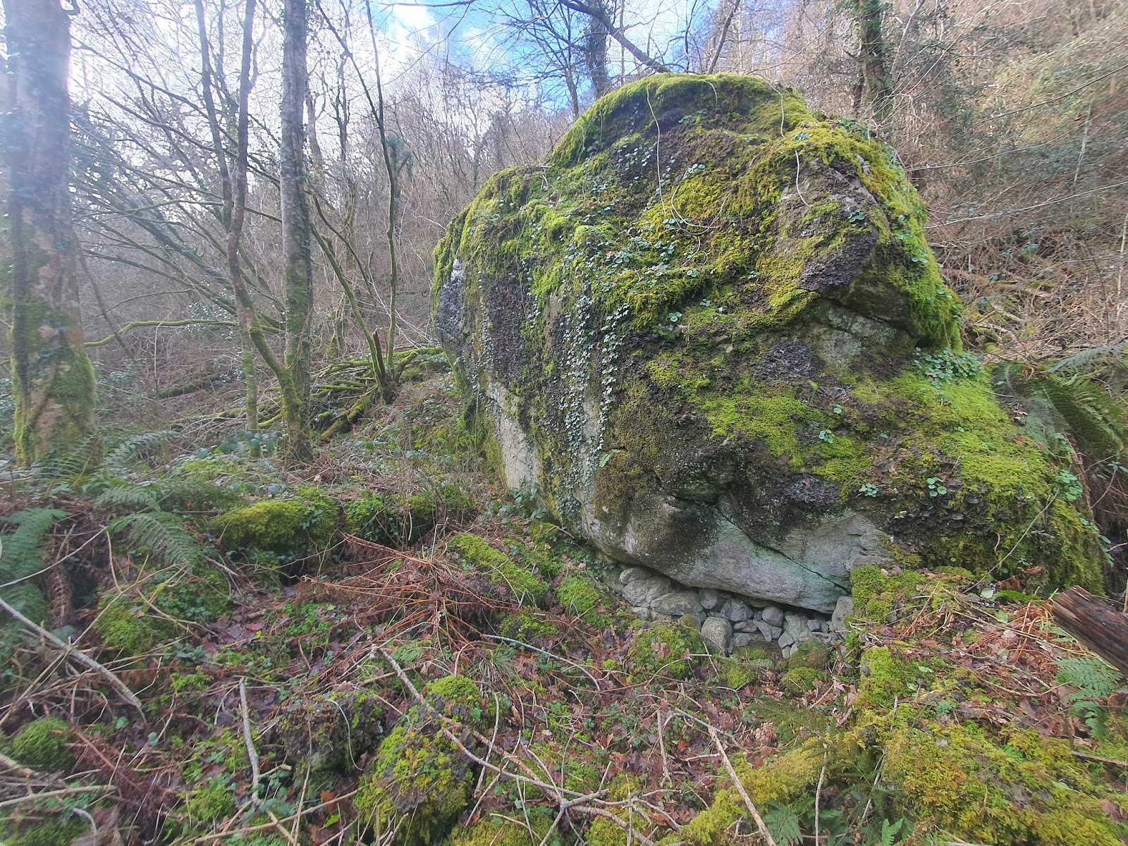
The outbuilding is built partly on a plinth of stones, something seen in quite a few of the older buildings in the area.

Soglog features heavily in the Welsh language pamphlet Adgof Uwch Anghof o Llanbedr-y-Cenin a Chaerhun, written by Parch T. Roberts around 1907. Evan Evans, a native of Ysbyty Ifan, had previously lived in Cwm Eigiau and worked as a shepherd, before falling out with his employer and leaving to move to Soglog. He had become involved in the temperance movement in Ysbyty Ifan after enjoying drinking and fighting as a youth, and had then become a Calvinistic Methodist preacher, moving to Cwm Eigiau at the age of 27. He had been active as a preacher in Cwm Eigiau, walking to various local chapels to hold services.

Soglog, when he moved into the house, is described as having a large chimney and a fire on the ground, and two rooms, a chamber and a kitchen, with hardly a boundary between them. The floor was of earth and the roof thatched with straw or rushes. This fits with the lack of slate on the ground around the ruin, which is usually quite obvious in houses that have had slated roofs.

Evan Evans still worked as a preacher while living at Soglog, but it's to be assumed that he had stopped working as a shepherd and had taken on labour in quarrying or other similar activities, given how he met his death at the age of 37. He was working on a level on the top ffrith at Coedty Bach with Griffith Roberts of Bwlch y Gaer when he 'rhywfodd yn ddamweiniol taniodd twll i'w wyneb' (somehow by accident shot a hole in his face). I'm not sure whether this means he was shot with a gun, or suffered some kind of explosives accident. Evans was able to walk to Coedty house, not far away, with the help of his friend. This was on the Thursday, and he didn't die until the following Sunday morning, 30th April, 1854. He was buried at the new Salem cemetery, leaving his wife, who was pregnant, and seven children.

Soglog is empty at the 1861 census, and doesn't appear in later censuses, so perhaps it was never lived in again.


The gable end of the building is still quite high, and the southern wall (left) looks as if it's probably at its original height, perhaps partly protected by being built into the slope. 


The wall opposite the gable end is quite low. Probably it was also a gable end which has collapsed. 


The doorway into the outbuilding is still obvious, at the left end of the north wall. There isn't much fallen stone inside. It seems likely to me that some of the stone was taken for dry stone walling, for reasons which will become obvious later. 


A view of the northern wall of the outbuilding, with its plinth of stone about three courses high.


I'm not honestly sure which part of the ruin this is, but it seems better to include the photo and find out later, than delete it.


To the east side of the house a little wall runs east-west, but it's impossible to tell if this were an enclosure or an extension of the house.


This north end of the house seems likely to be the fireplace end, given the thick wall and the large amount of rubble.

The earliest I've found the house so far has been in the Llanbedr y Cennin parish records, with a burial of 1709: Maria John uxor Ewani William de Mossoglog sepulta fuit secundo 7bris: Mary John, wife of Ewan William of Mosoglog was buried 2nd September.
 
The next entry is a baptism of 1746: William the Son of Richard Williams of Mysoglog and Jane Prichard was baptized January ye 29th 1745-6 [1746]. In 1750 Mary, daughter of William Williams and Sarah Jones of Mysoglog was baptized. In 1763 Owen, son of William Bowen and Elizabeth was baptized. This seems to show a relatively fast throughput of occupants.

In 1778 'Grace William of Mosoglog singlewoman' was buried. In 1787 William the son of Owen William of mossoglog by Margaret his wife was baptized, followed by another son, David, born to the same couple in 1789, and a daughter, Anne, almost ten years later in 1797. It is possible that Owen William is the son to William Bowen who was born in 1763, and that Grace William is a daughter to the same.
 
It seems that the house was still in the occupation of Owen Williams in 1814, when 'Soglog, part in Caerhun,' is mentioned as part of an estate sale in the North Wales Gazette. The place is also mentioned in the Caerhun Churchwardens' accounts in the 18th century, referred to as Tysoglog (or perhaps a misread Fysoglog?) in 1747, and Mysoglog in 1793, in the township of Rhwng y Ddwy Afon.


Another look at the fireplace end. The place is so collapsed and overgrown little can be made out. If the house was still thatched when it was abandoned it's no wonder that decay set in.


A large stone juts out from under the east-west running dry-stone field wall just in front of the trees, in line with the eastern wall of the house. It seems very likely that the house extended beyond the field wall, which, in that case, must have been built later, probably partly with stones from the ruined house.


It seems probable that this hump in the ground, behind the dry stone wall to the south, is the southern wall of the house. It lies parallel to the fireplace wall and at right angles to the side walls, and would be set between the two side walls if they were extended in a straight line.


The probable fireplace in the northern wall of the house.


Another look at the large amount of rubble in the fireplace wall.


The interior of the house is filled by this tree, and covered in moss, which seems apt given the house name.


In line with the western wall of the house, again it looks as if the house wall originally bisected the space that the dry-stone field wall now occupies.


The northern, fireplace, wall from outside.


The corner of the building looks quite well built, with large cornerstones.


Leaving Soglog, with the outbuilding on the left and the house almost lost under moss on the right.


Tuesday, 4 May 2021

The Lost Cottages - Cae'r Llin, Llanbedr y Cennin Parish

Cae’r Llin is a very ruined and overgrown little cottage high up on the edge of the Afon Dulyn, the river which flows down from Dulyn to the Afon Conwy in the valley below. On a calm day all that can be heard is the calling of birds and the hiss of the river fifty metres below. The house sits at 200 metres above sea level, surrounded by brambles and bracken and not on the public footpath. The house shows habitation from at least 1700, but occupation dies out after the 1861 census, and the place doesn’t seem to have retained any used trackways or paths as many of these places do. The name is mentioned in an estate sale of 1920, but likely simply as a piece of land.

The house would have had a few relatively close neighbours when it was inhabited; Pennant further down the river, as well as Cae Ithel Ucha and Cae Ithel Isa, Onen Ebryd on the hill above, and Llwyn Onn further up the river.

This post is made up of photographs from October 2020, and from May 2021.

See a video of the house here.


Approaching from the river below makes for a very steep climb up a slope which is carpeted in clawing brambles and tangled bracken, although the place sits relatively near to open farmland at the top of the slope. It seems to consist of a single detached outbuilding, with a long east facing cottage to the south with one outbuilding on the end.


 The gable end of the attached northern outbuilding seems relatively intact.
 
 
The stonework is still quite tight, and doesn't show obvious working to face the stones. It's hard to tell if the ridge was always at this height, or if the wall might have collapsed a little at the top.


There are good large cornerstones on this north-eastern corner of the little outbuilding, which is only a few yards across.


There was probably a door into the outbuilding in the centre of the photograph.


Just to the north of the house is the detached outbuilding, with only one wall still standing on the west side.
 
 
A long, slim stone stands about five feet from the wall, which looks as if it may have formed a low partition in the building. I've seen similar arrangements dividing one pigsty from another, so it's possible that this building was a pigsty. If there were walls on the other sides of the building they seem to have almost entirely disappeared. There are some slates leaning up against this large upright stone, so perhaps this little outbuilding had a slate roof at one time.


 The only remaining part of the south wall of this detached outbuilding is made from one very large stone.
 
 
Between the detached outbuilding and the house, on the east side, is what seems to be a single tall gatepost.


 A number of quite thick slates are lying on the ground, up on edge as if this is where they fell from the collapsing roof. Such coarse, thick slates point to this being a fairly early roof in the history of using slate.
 
 
The slate is very roughly split, and many of the slabs are about half an inch thick.


 A large tree has grown up on the back wall of the outbuilding attached to the house, which has probably displaced a lot of the stones.
 
 
A view of the gable end of this attached outbuilding from the inside.


The corner of the main house looks rather rougher than the outbuilding, and this gable end is certainly more ruined. It looks as if it were built separately from, so probably earlier than, the outbuilding.

The first evidence of occupation I have found is a baptism in the Llanbedr y Cennin parish records, when Anne, daughter of John ab Ewan and Grace ach Robert Parry was baptised in September 1700. Grace must have died at some point in the next few years, because the next entry is in 1707, when John ab Ewan's wife is called Gwenna Owen, and their son Owen is baptised on the 6th of April. They go on to have Elizabeth baptised on the 6th of January 1709, and Margaret on the 6th of April, 1715.

The next entry I have found is a burial in 1747, when Ellis Thomas of Cae'r Llin, widower, was buried on March the 15th.

There is a baptism for Anne, the daughter of Richard Roberts of Cae llin by his wife Jane on April 3rd, 1778, but Anne was buried on the 20th of the same month. Another burial occurs, perhaps with another new family in the house, in 1813, when labourer Hugh Hughes, 22, is buried on September 11th. It's unknown if Hugh Hughes was related to the next occupants, but at least from 1819 until the house's last appearance in the census in 1861, the place is lived in by Thomas Hughes, a farmer, and wife Margaret Hughes.
 
Baptisms seem limited to the church in Llanbedr y Cennin - perhaps the sensible choice for a fragile infant, because it's much closer than Caerhun church. There are a number of burials in Caerhun, though. In 1817 Ellin Hughes was buried at Caerhun, aged 15 months. I can't find a baptism record for her in Caerhun or Llanbedr. It is possible that she was the child of Thomas and Margaret Hughes. I can't find a marriage reference for the couple after 1813, either, and a period of a few decades before that is missing from the marriage records.

In 1819 Thomas and Margaret have another child Ellin, born on March 17th and baptised on the 21st. In 1821 their daughter Margaret is born, followed by Jane in 1824, and son John in 1827. Jane dies in 1832 at the age of seven, and is buried in Caerhun. Thomas Hughes of Caellin is buried in Caerhun at the age of 8, in 1849, but I can't find a baptism record for him. Catherine Hughes of Caer llin is buried in 1851 in Caerhun, aged 21, but I can't find a baptism record for her, either. She is mentioned in the census, though.
 
Curiously, although the census shows Thomas and Margaret continuing to live in Cae'r Llin up until 1861, in November 1835 Ellin, daughter of John Hughes, a farmer, and Anne Hughes is baptised. Perhaps there were more members of the Hughes family living in this small house.


 The inside of the cottage itself is full of undergrowth and trees, making it very hard to make out details.

The censuses for the cottage only show occupation until 1861, and through that time the house is lived in by the Hughes family. In 1841 Thomas Hughes is a farmer of 50, married to Margaret who is also 50, and living with children Margaret, 20, John, 15, and Catherine, 11. In 1851 Thomas is 58, a farmer of 35 acres - this differs from the 1846 tithe and the later census which show he has 50 acres. His wife Margaret is 62, son John 24, and Catherine 21; Catherine will die only a few months later. In 1861 the family no longer have children at home. Thomas is 69, a farmer of 50 acres, and Margaret is 73. They are living with a servant, Jane Jones, 13, and also have a visitor, 10 year old Margaret Jones who was born in Llangwstennin. The only record I can find subsequent to this is when Margaret Hughes dies at the age of 83 in May 1866, and is buried in Caerhun. This is quite an age difference to her age of 73 in the 1861 census.

It's unknown where the missing family members were baptised or buried. Perhaps they were occasional chapel goers, or sometimes used another church further afield.
 
 
The cottage disappears into the growth and it's impossible, without cutting back a huge amount of vegetation, to see the extent of the place.


 A wide angle shot inside the house, facing north, shows the ruin of the fireplace in the wall dividing the house from the northern outbuilding. It is relatively easy to make out the two thick walls to either side of the fireplace, with the slew of collapsed stone in the middle. It seems likely the fireplace had a wooden beam rather than a stone lintel, given this amount of collapse.
 
 
 The eastern end of the fireplace, with its thick wall.
 
 
 The western end of the fireplace is of a similar width, and has violets growing on the top. It's impossible to tell if the place ever had a bread oven, but given the early date that it went out of use, it's possible that it never did.
 
 
 There is a lot of rubble in the centre, which is typical of the sudden collapse of an entire chimney when the beam finally rots.
 
 
The western wall of the house has survived to about three feet high.


 The slope up to the house, an absolute tangle of bracken and bramble. It's hard to imagine quite how it would have looked in the past, or where any paths might have gone. There are a couple of tracks marked on the 1888-1913 Ordnance Survey map, though.
 

The 1888-1913 map, showing Cae'r Llin to the right, and Onen Ebryd to the top left. The Afon Dulyn flows through the valley below. Cae'r Llin is right on the edge of the treeline, with a few small enclosures to the north-west, and tracks leading north and then east towards Pennant further down the river, and north and then west to Onen Ebryd. The map shows a small enclosed space in front of the house, which is quite common in these cottages.

 
 The land just to the west of the house is a rather beautiful, spreading pasture, and is part of the field farmed by the occupant of Cae'r Llin in the 1846 tithe map.
 
 
 A little to the north west of the house is a number of small enclosures, on the land included in the tithe entry for the house, which were probably used by the farmer. In 1846 Thomas Hughes was farming two large parcels of land of a total of just over 50 acres, one centring on the house, and one up on the eastern slopes of Pen y Gaer.
 
 
 It's hard to make out exactly what the configuration of these pens might have been, but it seems likely they would have been used for sheep.
 
 
 This broad, spreading land is rather a surprise after fighting through the undergrowth from the river. Since the land is described in the tithe as arable, woods, and pasture, it seems likely the family were growing some crops up here as well as grazing livestock. Oats may have been grown, but the name 'Cae'r Llin' means 'Field of the flax,' and is mentioned in A Study of the Place Names of Montgomeryshire, in the journal 'Collections, historical & archaeological relating to Montgomeryshire' ('Cae'r Llin, The Field of the Flax," in Caernarvonshire'). It seems likely in that case that flax was grown here at some point.
 
 
 A little further from the pens and the house is what appears to be the remains of a walled trackway. On the 1888-1913 map a trackway is shown leading up to the farm and mill of Onen Ebryd, higher up the slope. If at one point Cae'r Llin produced flax, I wonder if it's possible that Onen Ebryd ever processed the crop. It has been mentioned that the place may have been a chaff mill, but I'm not sure what that involves.


Monday, 29 March 2021

The Lost Cottages - Pont y Gama, Llanbedr y Cennin Parish

Pont y Gama is a name that kept leaping out at me as I investigated various places around Llanbedr y Cennin and Caerhun. When researching the nearby Cae Ithel a newspaper story surfaced about Evan Roberts of Cae Ithel being asked to repair the Pont Gama footpath. At this point I didn't know where the footpath or the bridge were, but it seemed likely it was somewhere on the Afon Dulyn. The name crops up again in stories from 1916 about maintaining the bridge, here and here.

Later, while looking through the parish records for Llanbedr y Cennin, the name jumped out at me again. There is a 1701 baptism entry, which is hard to read since it's written in eighteenth century Latin. It seems to read 'Maria filia Johannis Foulk (molitoris de Pont y Cammau) & Elizabetha John Nicholas uxoris ejus baptizata fuit octavo Mart, 1701,' loosely meaning 'Mary, daughter of John Foulk, (?? of Pont y Cammau) and Elizabeth John Nicholas his wife, was baptised, 8th March, 1701.' This may be incorrectly translated and I'm not sure of my reading or meaning of 'molitoris', which must be John's profession, but essentially this means the house is mentioned in 1701. In 1718 there is another entry, 'Georgius filius Maurity[?] ap Robert (molitoxis di Pont y Camau) & Elin [illegible] uxoris ejus baptizata [illegible] July 1718.' The Caerhun marriage records for 1717 also contain an entry: 'Maurice Probert Ellis of Pont y Cammau and Ellin Edward of Allt Wyllt were married August 26.' These must be the parents of George.

Edit: apparently molitoris means 'Miller,' which may connect the inhabitants with the mill a little further downstream, or may indicate that Pont y Gama was a small mill or pandy.

A 1753 baptism entry for Llanbedr reads 'Margaret the daughter of David Morris of Pont y Cammau Weaver by Lowry his wife was baptized on Wednesday the 21 of August, 1753.'

Much of this post will necessarily be speculation. It's possible that the ruin found wasn't a house at all, or that a house at Pont y Gama was made of materials which mean that no trace remains, such as mud or wood. But there is a ruin very near Pont y Gama.


The Afon Dulyn flows down from Dulyn up in the hills to meet the Afon Conwy in the valley below.
 

The river is quite tame at some times, but it must be formidable when it's in spate.

Something of a wall runs along the back of the enclosure where the building sits. Perhaps once there was access along by the wall.


The building is here, a little space in front of a massive boulder. The structure is at Ordnance Survey grid reference SH 75992 68728.


This seems to be the doorway or entrance, in the east side. 


The tree on the left marks the south east corner of the structure, with the entrance just to the right.


The walls are no more than two feet high and the middle of the space is scattered with stones. Apparently the walls were rather higher some decades ago.


The back, northern, wall is this huge boulder. There are a lot of similar boulders scattered along the river. 


Inside the structure, looking at the eastern wall. 


Stones have been roughly packed under the edge of the rock. Would this be bothered with if this were simply an animal pen?


The western wall is also very low, with a gap or doorway at the north end.


The south western corner of this roughly square structure.


The southern wall is just as low as the others.


In the big boulder at the north west edge are a couple of apparently drilled holes. It's possible these held fittings for a door.


Outside the structure the boundary wall curves around and down towards the river.


The 1888-1913 map shows an unroofed building (marked in red) down below Pennant, on the side of the Afon Dulyn. A track appears to lead behind the building and on up the side of the river.


Looking back at the structure from the enclosure wall.


The river is quite close by. 


The enclosure wall has survived quite well.


Looking south west across the enclosure wall towards the river. 


From the west side, the enclosure wall looks quite substantial.


A wide angle shot shows the huge boulder in its entirety.


Back in the structure, looking east through the doorway. 


A closer shot of the doorway. 


The enclosure wall to the east of the building, running east-west, is largely lost to the undergrowth. According to the old map the path leads along behind this.


The enclosure wall as it approaches the boulder. 


Looking back towards the structure from the south east. It is true that if this were a house it would be a very small, mean structure, but a lot of very old houses were extremely primitive, some being made with mud walls, sometimes with a door only being made of a wattle panel that would be moved aside as needed, and possibly with no windows. Early houses wouldn't have had chimneys, but let smoke rise up through the thatch. So, while it's hard to imagine a family living here, it is a possibility. Proper excavation would probably have to be done to find out more about the place, though.
 

The line of the enclosure wall as it runs towards the path to Pont y Gama. 


Pont y Gama is obviously not a very ancient structure but it does have some age. The amount of discussion about this bridge and footpath in local newspapers around the start of the twentieth century implies it still held a good deal of importance at that time. 


The bridge from the west. This footbridge links the little cluster of houses on the north side of the river with the road between Tal y Bont and Llyn Eigiau on the south. 


The bridge is supported by large stone piers. Perhaps these are older than the metal bridge on top. It would be interesting to know what the earlier bridge looked like. In trying to find a meaning for Gama/Cama/Cammau one possible translation was camel, which seems unlikely, but I did wonder if at any point there were a humpbacked bridge here. [Edit: 'cam' can mean step, 'camau' being steps, and it has been mentioned that in the past there were stepping stones at the crossing rather than a bridge.]


The bridge stretches across to where the path continues up to the road on the other side of this deep river valley. Without this bridge, in rainy times and through a lot of winter, the river would have been very hard to cross.