Pont y Gama is a name that kept leaping out at me as I investigated various places around Llanbedr y Cennin and Caerhun. When researching the nearby Cae Ithel a newspaper story surfaced about Evan Roberts of Cae Ithel being asked to repair the Pont Gama footpath. At this point I didn't know where the footpath or the bridge were, but it seemed likely it was somewhere on the Afon Dulyn. The name crops up again in stories from 1916 about maintaining the bridge, here and here.
Later, while looking through the parish records for Llanbedr y Cennin, the name jumped out at me again. There is a 1701 baptism entry, which is hard to read since it's written in eighteenth century Latin. It seems to read 'Maria filia Johannis Foulk (molitoris de Pont y Cammau) & Elizabetha John Nicholas uxoris ejus baptizata fuit octavo Mart, 1701,' loosely meaning 'Mary, daughter of John Foulk, (?? of Pont y Cammau) and Elizabeth John Nicholas his wife, was baptised, 8th March, 1701.' This may be incorrectly translated and I'm not sure of my reading or meaning of 'molitoris', which must be John's profession, but essentially this means the house is mentioned in 1701. In 1718 there is another entry, 'Georgius filius Maurity[?] ap Robert (molitoxis di Pont y Camau) & Elin [illegible] uxoris ejus baptizata [illegible] July 1718.' The Caerhun marriage records for 1717 also contain an entry: 'Maurice Probert Ellis of Pont y Cammau and Ellin Edward of Allt Wyllt were married August 26.' These must be the parents of George.
Edit: apparently molitoris means 'Miller,' which may connect the inhabitants with the mill a little further downstream, or may indicate that Pont y Gama was a small mill or pandy.
A 1753 baptism entry for Llanbedr reads 'Margaret the daughter of David Morris of Pont y Cammau Weaver by Lowry his wife was baptized on Wednesday the 21 of August, 1753.'
Much of this post will necessarily be speculation. It's possible that the ruin found wasn't a house at all, or that a house at Pont y Gama was made of materials which mean that no trace remains, such as mud or wood. But there is a ruin very near Pont y Gama.
The Afon Dulyn flows down from Dulyn up in the hills to meet the Afon Conwy in the valley below.
The river is quite tame at some times, but it must be formidable when it's in spate.
Something of a wall runs along the back of the enclosure where the building sits. Perhaps once there was access along by the wall.
The building is here, a little space in front of a massive boulder. The structure is at Ordnance Survey grid reference SH 75992 68728.
This seems to be the doorway or entrance, in the east side.
The tree on the left marks the south east corner of the structure, with the entrance just to the right.
The walls are no more than two feet high and the middle of the space is scattered with stones. Apparently the walls were rather higher some decades ago.
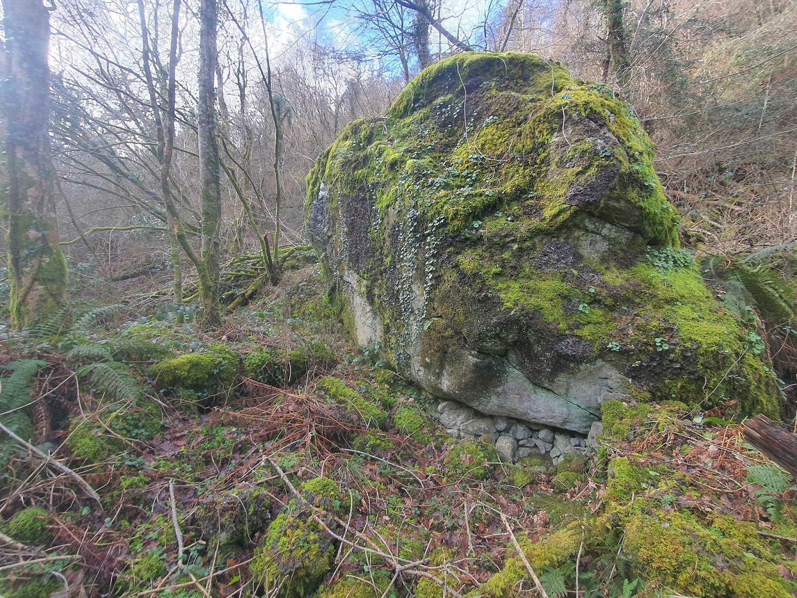
The back, northern, wall is this huge boulder. There are a lot of similar boulders scattered along the river.
Inside the structure, looking at the eastern wall.
Stones have been roughly packed under the edge of the rock. Would this be bothered with if this were simply an animal pen?
The western wall is also very low, with a gap or doorway at the north end.
The south western corner of this roughly square structure.
The southern wall is just as low as the others.
In the big boulder at the north west edge are a couple of apparently drilled holes. It's possible these held fittings for a door.
Outside the structure the boundary wall curves around and down towards the river.
The 1888-1913 map shows an unroofed building (marked in red) down below Pennant, on the side of the Afon Dulyn. A track appears to lead behind the building and on up the side of the river.
Looking back at the structure from the enclosure wall.
The river is quite close by.
The enclosure wall has survived quite well.
Looking south west across the enclosure wall towards the river.
From the west side, the enclosure wall looks quite substantial.
A wide angle shot shows the huge boulder in its entirety.
Back in the structure, looking east through the doorway.
A closer shot of the doorway.
The enclosure wall to the east of the building, running east-west, is largely lost to the undergrowth. According to the old map the path leads along behind this.
The enclosure wall as it approaches the boulder.
Looking back towards the structure from the south east. It is true that if this were a house it would be a very small, mean structure, but a lot of very old houses were extremely primitive, some being made with mud walls, sometimes with a door only being made of a wattle panel that would be moved aside as needed, and possibly with no windows. Early houses wouldn't have had chimneys, but let smoke rise up through the thatch. So, while it's hard to imagine a family living here, it is a possibility. Proper excavation would probably have to be done to find out more about the place, though.
The line of the enclosure wall as it runs towards the path to Pont y Gama.
Pont y Gama is obviously not a very ancient structure but it does have some age. The amount of discussion about this bridge and footpath in local newspapers around the start of the twentieth century implies it still held a good deal of importance at that time.
The bridge from the west. This footbridge links the little cluster of houses on the north side of the river with the road between Tal y Bont and Llyn Eigiau on the south.
The bridge is supported by large stone piers. Perhaps these are older than the metal bridge on top. It would be interesting to know what the earlier bridge looked like. In trying to find a meaning for Gama/Cama/Cammau one possible translation was camel, which seems unlikely, but I did wonder if at any point there were a humpbacked bridge here. [Edit: 'cam' can mean step, 'camau' being steps, and it has been mentioned that in the past there were stepping stones at the crossing rather than a bridge.]
The bridge stretches across to where the path continues up to the road on the other side of this deep river valley. Without this bridge, in rainy times and through a lot of winter, the river would have been very hard to cross.


No comments:
Post a Comment