This route is replete with history, being a natural pass over the mountains which does away with the need to follow the convoluted route around the coast. In winter the weather can be severe, though. It's more suited to feet and hooves than cars. The track runs directly from Rowen, down in the valley, and leads up over the pass to a crossroads where you can continue to Aber, hike up onto the mountain of Drum, or go right down into Llanfairfechan. It has been used from before the neolithic, by the invading Romans on their way to Caernarfon and Ynys Môn, by drovers bringing animals to market, by the farmers who still work the land, as a route for pylons, and by people taking their leisure in the mountains. The pylons are much lamented, but if we use electricity, pylons are one of the prices we pay for the luxury. When the A55 Expressway was planned, to improve the North Welsh connection to the port of Holyhead, the pass was considered as a route. Thank god they decided against it.
The whole route has antiquities, but the standing stones on this part of the pass are some of the most obvious. Further on, the map shows more cairns and burnt mounds, as well as an incised stone - a gaming board which is variously believed to have been carved by the Romans or the eighteenth century drovers. Back on the part of the road that leads down to Rowen are two more standing stones, and two rather lovely burial chambers, as well as hut platforms. This walk only took in the small stretch from the car park to the high point of the pass, though.


 The second of the less obvious cairns, at SH 7172 7157.


The track is an easy one of gravel and small stones, although parts do become small lakes when it's been wet. The track is used frequently by walkers and farmers, sometimes by mountain bikers. A few weeks ago a small convoy of quad bikes appeared after crossing the pass. The traditionalist and environmentalist in me would rather the only motor vehicles using it belonged to the farmers.

One of the small lakes. Easy enough to walk around.

From here you can just make out the standing stones, and, in the distance, the gate at the high point of the pass, from where you can see Ynys Môn.

I wanted to spend my time, this time, on trying to identify some of the prehistoric monuments on the pass. I don't know if this row of stones is associated with the Bronze Age inhabitants, but it's a very definite line. I didn't take a grid reference, but you can see the most obvious of the stone cairns just above and to the left.

What seemed like another line of stones pretty much at right angles to the smaller line. Looking from the end, it doesn't look so well lined up, though.

This cairn is one of four marked on the map in this area, but it's the only one that's so obvious. This one is called Barclodiad y Gawres (the same name as a burial chamber on Ynys Môn, and meaning 'The Giantess's Apronful. The reasoning behind this will become apparent later.) The two standing stones are just visible on the far right.
Coflein's description runs as follows: 'A rather irregular, somewhat oval cairn, c.20m E-W by 13.5m and 1.2m high, presenting an exposed cist, c.2.8m NE-SW by 1.3m, at its N fringe, possibly much disturbed/robbed.
(source: RCAHMW 1956 (Caernarvon I), 36 No.167, fig53)
RCAHMW AP45113/46-7
J.Wiles 03.06.04
2) A large cairn at about 1300ft above sea level in a natural depression falling gently to the S and joining the head of the valley of the Afon Tafolog. The cairn is much ruined but seems originally to have been oval or rectangular with a large cist on its N side. The cist is 58ft long and seems to have been about 4ft wide, but the side stones are much displaced. Many of the surface stones have the appearance of having been disturbed.

A wider shot of the cairn, with the high point of the pass in the distance. The cairn's Ordnance Survey Grid Reference is SH 7164 7165.

The cairn is surrounded by gorse bushes, with rushes at its centre.

There seems to be a little structure to the cairn, although I don't know how this reflects how it was originally. The stones seem to form something of a fat ring, with a hollow in the centre, where the rushes are. When there in person it's possible to make out something of a bank ringing the cairn, but, again, I don't know if this is original, built up later, or even just a flight of fancy on my part.

The cairn with the late sun shining down in the west over one of the lower humps of Drum.

I have no real reason for including this shot, except that I like it.

The cairn from the other side, looking roughly south east.

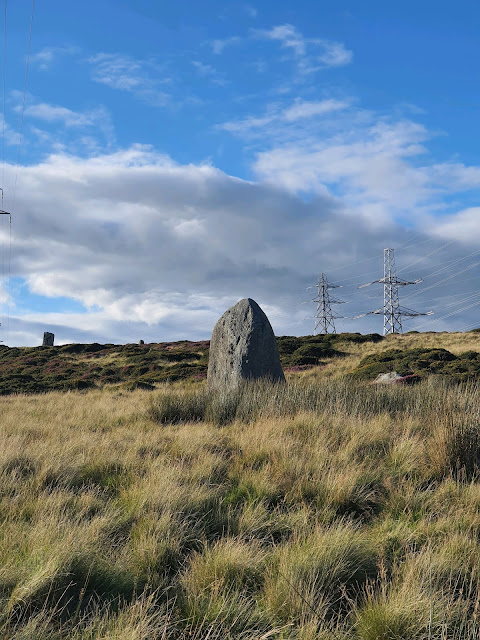
The first, and largest, of the standing stones. I see this stone as the female one; the other, smaller and squarer, as the male. Coflein says little about the stones that isn't already evident.
The local legend, as I've heard it and as my memory goes, is that two giants were walking over the pass; a woman and her husband. They were on their way across the pass, the woman carrying an apron full of stones and the man carrying two door posts, to build their house on Ynys Môn. But they had been walking so long that they were becoming tired, carrying this heavy weight of stones. As they approached the high point of the pass they met a cobbler coming the other way, with a sack full of worn shoes. They asked the cobbler how far it was to Ynys Môn, and he told them that the shoes in his sack were all the ones he'd worn out, walking from Ynys Môn. The giants stopped, refusing to go further. The female giant threw down her apron of stones, which became the cairn. The male threw down the door posts, which became the standing stones.
I've also heard the variation that it was only the female giant carrying stones, which she threw down. The two giants stood on the pass, arguing, as the night passed by. They were so engrossed in their argument that they didn't notice the coming dawn. When the sun came up, they were turned to stone, and there they've stood ever since.
I prefer the second version. Either way, if only they'd made it a few more yards to the top of the pass, they would have been able to see Ynys Môn, and they would have known they were almost there. Perhaps this is a morality tale about perseverance?

The largest of the stones, what I see as the female of the two. The other can be seen on higher ground, just to the left in this photo.

The sun lowering behind the female stone.

Looking back along the bwlch, the farmers' track leads across the left of the photo. A scar in the land between the track and the large pylon is probably the path of the Roman road. The peak in the distance is Pen y Gadair.

While I was busy taking photos of standing stones, my husband called me over to the track. In the lowering light he'd noticed something curious.

This stone, embedded in the track, seems to be carved.

It was easier to make out in person, but I've gone over the lines we saw in red. Something like a square, parallel lines in the centre, and three rings at the top. Is this ancient? Neolithic, Roman, something scratched by the drovers? Or something completely modern? I don't know enough about these things to make a guess.

Looking back along the track to the east, with the scar of the Roman road going to the left of the newer track. The other side of the valley is just visible in the distance.

The 'male' standing stone on the left, and a much smaller stone just to the right of it. This stands on the other side of the track from the female stone.

In this photograph, the small standing stone looks much larger. In reality, it's only about knee high.

The small standing stone. Perhaps the giants had a child?

The larger standing stone, although this is still smaller than the female one on the other side of the track.

The male stone, with the smaller stone to the left. A little further away, beyond the two, is another, smaller, upright stone.

The view from the top of the pass. If only the giants had made it a little further, this is what they would have seen. Ynys Môn, with Ynys Seriol (Puffin Island) to the right.

A wider view, with the track leading off to the left. To be fair to the giants, it's still quite a way to go.

Turning round to go home, this is the first of the cairns marked on the map. At least, I think it is. This rise in the heather and gorse corresponds with the Ordnance Survey mark at SH 7137 7184. Worth wading knee high through gorse to reach? Maybe not, but I did it anyway.
Coflein has this to say: A 60ft diameter cairn with traces of a kerb on East. One side of a cist, 5' long with axis NW-SE is exposed in the centre. The cairn is situated on a ridge formed by an artificial hollow on the SW and a natural scarp on the NE, which makes it difficult to provide a realistic diameter or height. RCAHMW recorded a cist exposed in the centre and two vertical stones may be the remains of this, although they are now on the SE edge of the surviving mound. The cairn is situated between the track (Roman road) and a dry gully on a naturally raised area. It is an oval mound of turf covered stone 6m by 4m. The cairn has probably been truncated by the gully on the SW side. On the ESE side are two low stones laid on edge.

Either side of the cairn are grooves in the land which I've always taken to be associated with the Roman road. Presumably if the cairn sits between them, they're not Roman.

One of the grooves, lining up with the track of Roman road in the distance.
 The second of the less obvious cairns, at SH 7172 7157.
Coflein's description is as follows: 1) A round cairn, c.10.8m in diameter and 0.3m high, showing traces of a kerb of upright stones.
(source: RCAHMW 1956 (Caernarvon I), 36 No.169)
RCAHMW AP945113/47
J.Wiles 03.06.05
2) A cairn about 110m SE of Barclodiad y Gawres which survives as a ring of turf covered stone 2m wide. There is a large boulder on the N side with evidence of a recent fire against it. Based on information from the GAT SMR. Site as described. 2004.03.30/OAN/PJS

At first it's hard to make anything out, but there's a definite scatter of stones on the ground here.

Something of a circular shape can be made out, a little higher at the edges.

The third of the marked but hard to see cairns, on the other side of the track at SH 7183 7159. This one is the hardest of them to make out, and I can find nothing on Coflein about it, although it's not the easiest site to search. There is a scatter of stones here but I wasn't directly on the map marker according to my phone's GPS. I was very close to the power lines, which might have affected things.

Really, it's hard to see anything certain here, as with a lot of cairns, apart from these few stones. Sometimes I wonder if Ordnance Survey map makers throw darts at the map and vicariously note down cairns, burnt mounds, and settlements. I might be getting at bit better at spotting them, though, with the help of the GPS on my phone.
With the last of the cairns tentatively identified, it was time to go home for a cup of tea.
No comments:
Post a Comment